


Industrial decision makers are getting more demanding. Be it infrastructure, energy, or other asset-heavy sectors, satellite data is now expected to do more than provide just visual coverage. It has to support decisions about risk, compliance, and asset condition in a way that are trusted and consistent over time.
This shift is already visible across some sectors. In mining, operators are expected to demonstrate stability and environmental performance almost in realtime and not just at fixed reporting intervals. In utilities, vegetation management and network integrity must be monitored across thousands of square kilometres. In insurance, underwriting and claims validation depend on verifiable ground conditions rather than one-off snap assessments.
Across these use cases, the requirement is the same: data that can be relied on as evidence over time, not simply viewed as an image.
Industrial Decisions Need Proof
The scale of this challenge is well documented. McKinsey estimates that predictive maintenance and condition-based monitoring can cut maintenance costs by 10 to 40 percent and reduce downtime by as much as 50 percent. The value of seeing asset condition earlier and more consistently is no longer hard to quantify. When operators only see asset condition at intervals, important changes can build quietly between inspection cycles.
Advanced analytics and machine learning are reinforcing the same shift. Operators want earlier warnings, better foresight, and a clearer basis for action. That kind of workflow depends on data that is consistent over time.
In 2025, Swiss Re puts global insured losses from natural catastrophes above $100 billion, with infrastructure exposure accounting for a growing share. Risk on the ground does not stand still between events or reporting periods. Without consistent monitoring, it is much harder to judge how that exposure is changing.
For operators, periodic checks are no longer enough. They need a baseline that allows change to be detected, compared, and verified across time and across assets.
Why Imagery Alone Falls Short
Satellite data has expanded visibility. Large and distributed assets can now be observed regularly without the constraints of physical access. For many years, that was enough. High-resolution imagery supported mapping, inspection, and situational awareness.
Industrial workflows have moved well beyond one-off analysis. Data now feeds operational systems, risk models, and automated processes. That raises the standard. The data has to stay consistent over time and usable inside systems that depend on that consistency.
AI and advanced analytics have made the requirement more explicit. As a recent World Economic Forum article on Earth observation and AI notes, the real value comes from turning raw data into meaningful signals that preserve patterns across space and time, not just from collecting more pixels.
This makes consistency critical, as current observations of the same location often differ from one pass to the next. Acquisition time changes; viewing angles shift; atmospheric conditions vary; and sensor response is not identical. These differences introduce variation in the data even when nothing on the ground has changed.
For visual interpretation, this can be managed. For systems that depend on consistent inputs, it becomes a constraint. Data has to be aligned, corrected, and normalized before it can be used, adding complexity and time as well as reducing reliability at scale.
What Measurement-Grade Data Changes
The real requirement here is repeatability. The same location has to be captured consistently enough that the data can be compared over time with confidence. Without that, changes in the signal can just as easily reflect shifts in acquisition conditions as actual changes on the ground.
Newer Earth observation systems are being built around this emerging requirement. Constellations designed around coordinated imaging, controlled viewing geometry, and calibrated multi-spectral observation are structured to produce consistent measurements rather than isolated images.
Spectral range becomes useful here in a very practical sense. Different bands capture different signals, from plant stress and moisture levels to heat patterns and material changes. Collected consistently over time, they make it easier to see gradual shifts that a single image might miss.
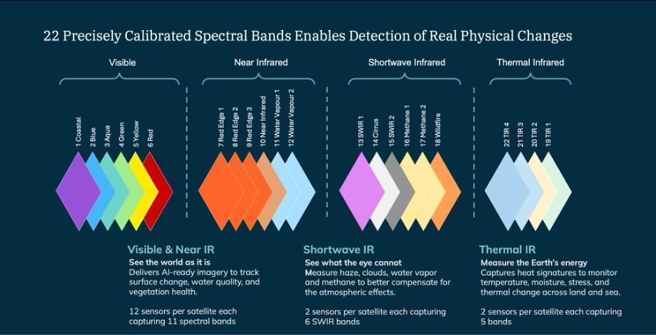
EarthDaily’s 10-satellite constellation is designed to capture consistent, calibrated measurements across 22 spectral bands, enabling detection of real physical change across land, water, vegetation, and atmosphere.
Systems like EarthDaily are built around this requirement. The EarthDaily Constellation combines wide-area daily coverage with calibrated, multi-spectral measurement across 22 spectral bands, allowing data to remain comparable across passes, sensors, and satellites. The result is a stable dataset that can be used directly in industrial workflows.
Earth observation then becomes part of the monitoring system itself. EO-based measurements can be used to track condition, verify change, and support decisions across large and distributed operations.
As industrial systems become more automated and decisions become more data-driven, the requirement for measurement-grade observation will continue to grow at pace.
Author bio
Peter Round is Head of Europe and Global Vice President, Business Development – Defence & Intelligence at EarthDaily. A retired senior officer of the UK Armed Forces, he served for 33 years, including postings in the United States and Brussels. He represented the UK at NATO Supreme Allied Command Transformation in Norfolk, Virginia, and later served as Capability Director at the European Defence Agency, leading more than 100 multinational capability and research programmes. He is a Fellow and Chair of Trustees of the Royal Aeronautical Society and a Consulting Senior Fellow at the International Institute for Strategic Studies.